It’s early May. Still chilly water averaging 8C/46F. Hardy dry-suiters have been in but I like to wait until the river hits 15C/60F (or close).
Weeds are at their lowest point of the year – not much of a factor until at least mid-June, so chilly or not, it’s an excellent time to see a clear dive site. But spring’s also notorious for a lot of plant “guck” suspended in the water. Smile anyway – you can’t have everything!
Today the river has been calm and the water level relatively low, which seems crazy with all the flooding around us. It’s a good opportunity to explain why this is so.
Lake St. Lawrence
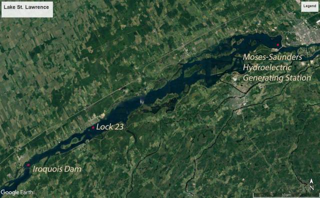
When the St. Lawrence Seaway was created (opening in 1959), one of its projects was the construction of two dams in this area: The Moses-Saunders Hydroelectric Generating Station at Cornwall and the 32-gate Iroquois Dam at, you guessed it, Iroquois.


The river in between was raised 30 feet to cover some major hazards to navigation – the treacherous Long Sault Rapids, the less dangerous but still formidable Rapides Plat near Morrisburg and the upstream narrowest section of the river with its extreme current.
For more information on the tremendous impact of the Seaway on inhabitants along the river, refer to Lost Villages.ca or St. Lawrence Piks.com.
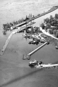
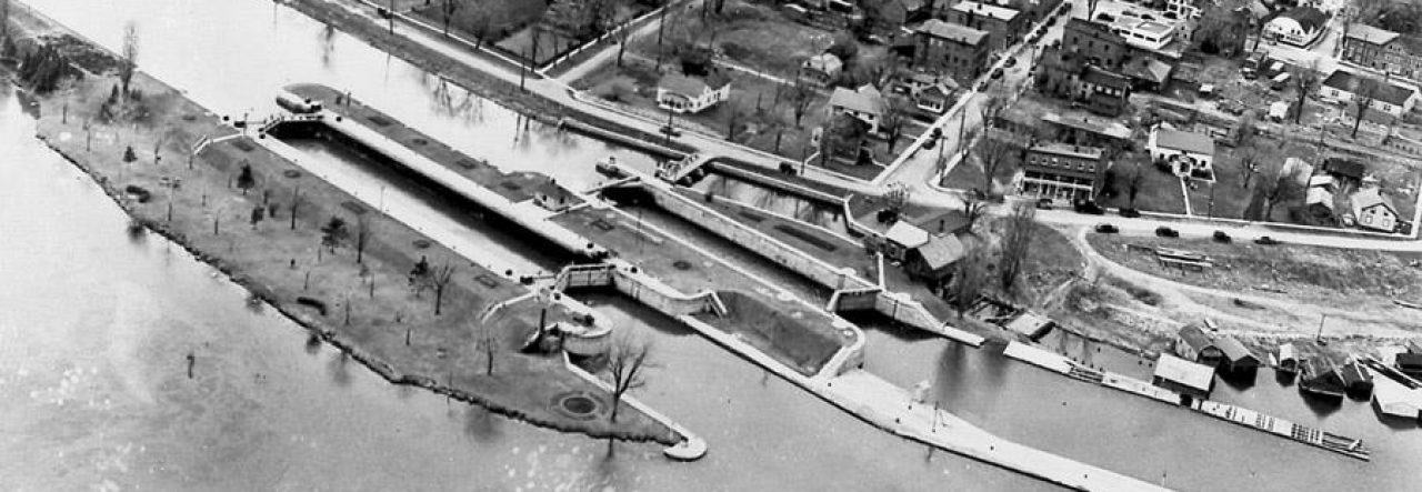
The most important point to keep in mind today is that between these two dams a lake was created: Lake St. Lawrence (LSL). To the eye it still looks and behaves as a river, always flowing east, but can be raised or lowered as a single space between the two dams. Today’s towns of Iroquois, Morrisburg, Ingleside and Long Sault are all located on the banks of this new lake. On the Canadian side, Lock 23 at Morrisburg and Lock 21 near Long Sault, lie 30 feet below the water’s surface.
How is river flow managed and how does it affect diving?
Water flows out of Lake Ontario (it’s called “outflow” – surprise), passes through the Thousand Islands, then the Iroquois Dam (which in normal conditions has all its gates open) and into Lake St. Lawrence, where it continues its way to the Moses-Saunders Dam in Cornwall. It is at this second dam, where the gigantic hydroelectric plant is housed, that decisions are made to control the outflow from Lake Ontario, 160 km upstream.
If water levels are too high in Lake Ontario, perhaps due to extreme weather or increased inflow from the other great lakes, the gates are opened at Cornwall, and the waters within Lake St. Lawrence (LSL) drop.
If water levels are too high beyond Cornwall, such as with flooding in the Montreal area, the gates are closed at Cornwall, and the waters within LSL rise.
The gates at Iroquois can be adjusted to maintain levels up or down within LSL in conjunction with the changes made at Cornwall. Levels within LSL itself must also be managed for safe navigation in the current, the ability of freighters to carry more cargo, prevention of shoreline flooding, and management of local water intake needs (hydroelectric power, water supply, irrigation, etc.).
Check out the International St. Lawrence River Board of Control for information on water level management. There are some excellent teaching videos on the site.
When LSL levels change but conditions remain relatively normal, not a lot changes from a diver’s perspective. The current stays roughly the same but navigation strategies relying on depth must be modified. Low levels however can also be combined with faster flow… this causes turbulence around the Lock walls which can dramatically affect dive conditions.
What happened in 2017?
In the early spring, there were extreme weather conditions leading to both upstream and downstream flooding. There was highly variable ice formation (more about that here). Tremendous increases in outflow created a situation where water from a flooded Lake Ontario was released into a flooded Lake St. Lawrence. Then April and May were the wettest on record. Lake Ontario rose to its highest level in 100 years and there was severe shoreline damage all along the river.
Outflow was increased to its absolute safe maximum which created extreme low water in LSL, high currents, and treacherous eddies in and around the dive site. There was next to no visibility. The outflow ultimately had to be lowered somewhat despite flood concerns because freighters moving upstream were unable to manage the current.
What’s happening in 2019?
Throughout 2018, outflow remained higher than normal as management sought to slowly bring Lake Ontario levels back to normal. LSL remained very low all summer and divers adjusted to a mere 10-foot distance between lock wall tops and the river’s surface by adjusting navigation techniques, especially on approach, and being ultra-aware of small boat traffic above.
So far this year, most of the extreme weather conditions have been associated with the Ottawa River which empties into the St. Lawrence at Montreal. Some levels in that area have in fact been higher than in 2017. Water in Lake Ontario however remains within historical ranges and well below those of 2017.
Continuing widespread rains are expected to create a need for high outflows and a subsequent reduction in the level of LSL… but as of today, downstream levels have peaked and should slowly reduce, allowing the level of LSL to slowly rise. All gates at Iroquois are currently closed.
I’ll follow up should anything major develop.
Sydney
